During the work week, I am often on Queen Street at noon.
Sometimes I shop for something we need at home.
Other times, I just walk--down the great hill and back again--for fresh air and exercise after spending the morning at my desk.
Wednesday, 23 September, was different. I had a meeting at the Tamaki campus. I caught the train at 9:55 a.m. and headed east to work at the Composites Centre.
When I got home, Lucy asked me how things went and whether I was on Queen Street at noon.
"No, I was at Tamaki today" I replied. "Why," I asked.
It was the annual Boobs on Bikes parade down Queen St.
Yahoo news reports that "Downtown Auckland ground to its annual halt today as the city's main street was taken over by naked breasts, motorcycles and thousands of men armed with mobile phone cameras.
More than 80,000 people were estimated to have visited Queen St on a gray and occasionally showery day to attend the annual Boobs On Bikes parade"
Missed it by that much.
Wednesday, September 23, 2009
Tuesday, September 22, 2009
Brace Yourselves!

Since we first got the car, I've wanted a four-way lug wrench.
I've never liked the stock wrench that comes with the car; a lug wrench is your best friend if you get a flat on the road.
I finally found a car parts shop within walking distance from the rail station near Tamaki campus. What I thought was a part place was a repair shop. The next shop was a panel-beaters and more repair places lined the road. There had a to be a parts shop with wholesale prices to the shops and retail prices to the public.
A few more blocks and I found it: Repco Auto Parts.
I couldn't find the wrench, so I asked at the counter.
"Hello, I need a lug wrench."
"A what?" came his reply.
"A wheel lug nut wrench?" I asked more than stated.
He thought a bit, and I crossed my forearms and said "For changing tyres." I tried to make the Y in tyres stand out.
"Jacob! Take this gentleman to aisle seven and show him a wheel brace."
Yes, that's what I wanted.
Monday, September 21, 2009
A Different Scale
The scale of this great country keeps popping up in the news.
When we arrived, the unemployment was 50,000--nationwide*.
This morning, they noted that 8509 persons are in prison and jails--nationwide.
The NZ prison rate is 1 per 562 persons.
Texas has 72,000 cells. USA national imprisonment rate is 1 per 133 persons.
The prison population is in the news here because they are warning that they might have to move from 1 person in a cell to double-bunking some prisoners.
>>Correction: There is already some double bunking. The government is warning that more might be needed.<<
*This was considered shocking at the time. Unemployment in July 2008 was about 2,000 persons. Since our arrival the unemployment reached 142,000; the world economy is hitting hard here.
Sunday, September 20, 2009
About flickr.com
Howdy:
We hit the 200 photograph limit and paid for a flickr.com pro account.
No limits, no worries.
Lucy wants me to add more upgrades:
1) I'll put a link under each photo that will get viewers back to the blog without a lot of fussing about.
2) Please note that if you watch the slideshow at flickr.com, you will not see the captions. I'd rather not mess with the photos by burying the captions in them. So, you have the option of clicking through the slide by clicking the next photo in the set. The image below shows the place to click with red arrows. The blue arrow points to the slide show button that runs the set in full-screen without comments.

I'll add a Return to Blog link under each photo that I add going forward.
P.S. I found the tool in Picture Manager that lets us make the horizon level. My LCD sun shield broke off when we dropped the camera in Rotorua. It finally fell off in Alan's van. Now we're shooting photos in bright sun and cannot really see the details. So our horizons are a bit off. I'll fix those going forward.
No worries,
Terry
We hit the 200 photograph limit and paid for a flickr.com pro account.
No limits, no worries.
Lucy wants me to add more upgrades:
1) I'll put a link under each photo that will get viewers back to the blog without a lot of fussing about.
2) Please note that if you watch the slideshow at flickr.com, you will not see the captions. I'd rather not mess with the photos by burying the captions in them. So, you have the option of clicking through the slide by clicking the next photo in the set. The image below shows the place to click with red arrows. The blue arrow points to the slide show button that runs the set in full-screen without comments.

P.S. I found the tool in Picture Manager that lets us make the horizon level. My LCD sun shield broke off when we dropped the camera in Rotorua. It finally fell off in Alan's van. Now we're shooting photos in bright sun and cannot really see the details. So our horizons are a bit off. I'll fix those going forward.
No worries,
Terry
Saturday, September 12, 2009
To Tapatupotu Bay

We searched for the trailhead. A driver told us that we could get to the bay by walking downhill 1 km to a gravel road and walking that down to the bay. Hardly a great walk, it would save time. We wanted to walk along the Pacific ocean now that we had left the Tasman sea behind.
We headed back to the lighthouse and found the trailhead--it dropped off a hairpin turn in the lighthouse footpath.
We started down a friendly downhill trail to Sandy Bay. Then we faced it. A New Zealand switchback to the next ridge. (A New Zealand switchback is little foot spaces carved right into the hillside. It's like a mud ladder. It goes straight up.)
This was the major part of the 2 1/2 hours ahead of us. We got 1 photo during the climb. We were too tired to push the shutter.
Emily and Benjamin raced ahead, but Lucy and Terry dropped to the ground at the top and sat and drank water for 10 minutes before starting off again.
We noticed that the DOC recommends a counter-clockwise path for this walk. That would provide gentler climbs and one steep descent to Sandy Bay.
This was the only hill the guidebook described as 'steep.' This was rated 'easy.'
We reached the high point and saw our camp--it seemed so close. Horizontally, it was close, but we still had to descend to the beach.
We finished this leg in 1 1/2 hours, one hour less than the book. That was great; we needed the time to pitch the tents--on flat, level ground with soft mushy grass under them--and to get supper.
We played Hearts in one tent until we started to get too cold. The Pacific breeze seemed a lot colder than our first night.
Emily had a tough time keeping warm enough--her side of the tent was broadside to the wind from the ocean. Benjamin and Terry pitched their tent so the rain fly would deflect the prevailing breeze and they slept well.
The next morning, Alan arrived 15 minutes early and we had to rush the last bit of packing.
A short van ride to the car and we raced 6 hours to make the auto ferry home to Waiheke.
Mischief managed.
Photographs here.
Cape Reinga
Click here for three photos.
The high resolution photo:
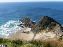
The Maori believe that the souls of the dead travel to this point, climb the roots of the 800 year old Pohutukawa tree and leap to the afterlife.
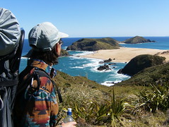
At the Cape Reinga lighthouse, we dropped our packs and walked down to the lighthouse. There were many people there; you can drive to a visitors center and walk down to the lighthouse.
We had a final trek: Taputopotu Bay. The guidebooks said it takes 2 1/2 hours. It would be dark by then. We couldn't find the trailhead. We had to hurry.
The high resolution photo:
The Maori believe that the souls of the dead travel to this point, climb the roots of the 800 year old Pohutukawa tree and leap to the afterlife.
At the Cape Reinga lighthouse, we dropped our packs and walked down to the lighthouse. There were many people there; you can drive to a visitors center and walk down to the lighthouse.
We had a final trek: Taputopotu Bay. The guidebooks said it takes 2 1/2 hours. It would be dark by then. We couldn't find the trailhead. We had to hurry.
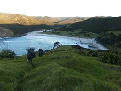
Te Werahi Beach
Click here for the photos.
We continued along the sand ridge. Just as the terrain turned green again, we had to decend to Te Werahi Beach and cross a stream.
We took off boots and socks, rolled up our trousers, and scooted across the cold fresh water.
After another beach walk, we stopped for lunch and watch the gulls and an albatross fly around .
When we climbed to the ridge on the far side, we could see the Cape Reinga lighthouse.
Here is this set's high resolution image:
Friday, September 11, 2009
Motuopao and Taupin Islands
We found that the Google satellite view shows the trails overlaid on the photo. Typically, the trails are wrong. The photo shows the trails that were there when the satellite passed overhead. Those trails were closer to the trails that we followed.

This photo appears at full resolution in the flickr set here.
We were standing in the white circle in the satellite photo. It was so handy that the DOC painted that white circle on the ground!

This photo appears at full resolution in the flickr set here.
We were standing in the white circle in the satellite photo. It was so handy that the DOC painted that white circle on the ground!
Camp Alpha

This is Google's satellite view showing our camp above Twilight Beach. The Department of Conservation (DOC) rep knew that the camp site was no longer maintained and that we might have trouble finding it. "You can always camp on the beach," she told us. That didn't really reassure us. We knew the tide times for our trip and we knew that Twilight Beach would reach high tide at we slept.
This image shows the beach at high tide--there is little dry beach left at this end. We could tell that when we arrived. If we didn't find the camp site, we'd have to camp over the dunes so that we could stay dry.
The blue arrow shows the stream and its flow to the beach. We refilled our water bottles--using our filter--the next morning before we moved onto the desert trek.
The red circle shows our campsite.
Infrequently during the night, we heard a deep boom. Lucy and I compared notes the next morning; we both though "if we were near a military base, I'd think they were doing practise bombling." Yes, we met while working in aerospace!
On a morning walk for solitary reflection on our life on earth and our place in the universe, Terry crossed the low ridge between the yellow and red circles. While studying the northern view he heard the boom again. Seconds passed and then the spray reached the ridge! It rose high above the ridge and crashed down to the ground. Occasionally, the sea would send a great wave to the wall at the lower left. The wave hits the wall and sends the water over our heads. Incredible. Good thing we didn't put the tents up there.
We packed the gear, climbed down to the beach, and took the trail (brown arrow) toward the desert.
Twilight Beach--Satellite View

After walking through the green landscape along the ridge between 90 Mile and Twilight breaches, we decended to Twilight and finished the six miles at the beach's northwest end.
The changes from green to sand and back again are so sharp. The terrain is like a micro-continent.
Another View
Here is a satellite view:

At the lower right you can see Te Paki stream and where its mouth reaches the ocean. We walked to the upper left along 90 Mile Beach. The great sand areas behind the beach are dunes; folks rent boogie boards and go dune surfing. Our driver, Alan, offered to bring 4 boards along to our Sunday pickup; however, we had a tight schedule for driving to the ferry by 6:30 p.m. We'll have to sand dune surf another day.
In the green area at the upper left corner, we found the stairs and too the ridge path to Twilight Beach.
Goodbye 90 Mile, Hello Twilight Beach
We climbed the stairs to the ridge and continued to twilight beach.
At the far end of the beach, we found the stream noted in the guide book. We were to 'go upstream' and climb to the campsite.
I couldn't get far upstream before the stream narrowed and I could go no farther.
Lucy spotted the footpath--very narrow in the grass--and followed it to the top of a bluff over Twilight Beach's north end.
As we set up Camp Alpha, the beautiful clouds turned to rain clouds. The rain was slight and stopped just as we put the rain flys on the tents.
Terry found out his waterproof jacket wasn't.
The wind came up, he took a serious chill, and dashed to the tent for dry clothes and his sleeping bag.
Lucy, Emily, and Benjamin prepared the meal and Terry recovered with chicken and rice soup, freeze dried beef teriaki, and a final cup of hot water.
The camp was on a hillside, we all spent the night sliding downhill, waking up, moving the bags and pads uphill, and sliding down again. Each slide cycle gave us an hour of sleep.
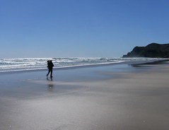
Photos, one--Lucy and Emily walking the beach--available in full resolution if you click the All Sizes spot over the photo.
http://www.flickr.com/photos/9117880@N07/3909468950/in/set-72157622336619914/
At the far end of the beach, we found the stream noted in the guide book. We were to 'go upstream' and climb to the campsite.
I couldn't get far upstream before the stream narrowed and I could go no farther.
Lucy spotted the footpath--very narrow in the grass--and followed it to the top of a bluff over Twilight Beach's north end.
As we set up Camp Alpha, the beautiful clouds turned to rain clouds. The rain was slight and stopped just as we put the rain flys on the tents.
Terry found out his waterproof jacket wasn't.
The wind came up, he took a serious chill, and dashed to the tent for dry clothes and his sleeping bag.
Lucy, Emily, and Benjamin prepared the meal and Terry recovered with chicken and rice soup, freeze dried beef teriaki, and a final cup of hot water.
The camp was on a hillside, we all spent the night sliding downhill, waking up, moving the bags and pads uphill, and sliding down again. Each slide cycle gave us an hour of sleep.
Photos, one--Lucy and Emily walking the beach--available in full resolution if you click the All Sizes spot over the photo.
http://www.flickr.com/photos/9117880@N07/3909468950/in/set-72157622336619914/
Wednesday, September 9, 2009
Ninety Mile Beach--Our 14 Mile Hike Begins
We walked the last 45 minutes of ninety mile beach and climbed the stairs at its north end.
The view from the ridge is available in full-screen.
(So far, I've blogged the first 45 minutes of the walk itself. We've been working behind the scenes. We whittled about 300 photos into the few we'll share online.)
Click here for a short video and 6 photos.
The view from the ridge is available in full-screen.
(So far, I've blogged the first 45 minutes of the walk itself. We've been working behind the scenes. We whittled about 300 photos into the few we'll share online.)
Click here for a short video and 6 photos.
Night in Kaitaia, Morning Drive to Waitiki Landing
We stayed in a motel with a family suite. We didn't know what that was, but the adjoining rooms included a kitchen with dishes, microwave, electric cook top, electric kettle.
Really great for $125 for the four of us. We would have brought breakfast fixings if we knew it was going to be that furnished.
We had a great breakfast at Birdie's cafe--all the cafes here are great, we've avoided all the chains (McD's, Starbucks) because you can get great coffee and food at a local cafe.
To save blogging time, I put captions on the photos. Click on the link below to see our drive down the Te Paki Stream Road and on down the stream itself.
http://www.flickr.com/photos/9117880@N07/sets/72157622158937169/
Walking alone for 26 hours.
Toll tags? We don't need no stinkin toll tags!
We took the short route through the new "everybody has a license plate, so who needs a toll tag" motorway.
You can read all about it at
http://www.landtransport.govt.nz/tollroad/
Because we would be away from the internet for a few days, we decided to stop and prepay for tolls both ways. On Sunday we could avoid the lines and just cruise on home.
We typed our license plate number into the kiosk and the system told us to confirm our car as a 1993 Honda Ascot. I selected two trips and added $4 in coins.
We got back on the road and drove under the cameras. The system measures your vehicle and assigns the toll against your license plate number.
Your license plate is your toll-tag. Although toll roads are a drag, this was cool.
(I logged on after we got back. Yes, they billed my pre-pay for both tolls.)
Monday, September 7, 2009
Ferry, Drive, Motel in Kaitaia
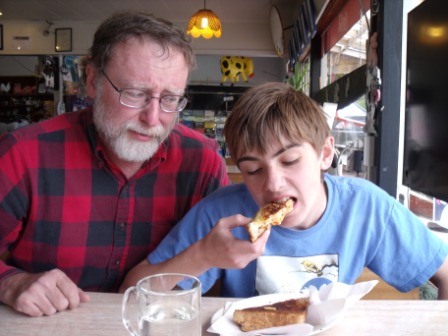
Benjamin finds a new comfort food.
We took our car over on the auto ferry; did a better job navigating to Route 5 and finding Motorway 1; and went north past Auckland for the first time.
Driving is work. The road is never straight or level for long. Once the motorway changed into a two lane road, we were always shifting between D3 and D4 and accelerating/slowing to adjust to the curves.
It was a five-hour roller coaster ride. We were delaying lunch to make better time, but Benjamin declared himself carsick and we found the Swinging Cow.
We had a great lunch. Benjamin discovered his new favorite: the toasted spaghetti sandwich.
Yes.
For Photos Click Here
Sunday, September 6, 2009
Two Days Tramping in the North


The kids had two days school holiday and the university is on spring break, so we went to north North Island for a two day trek.
This let us try out the gear before the longer treks. We walked six miles on the first day and eight on the second with two nights spent in tents.
We made it through quicksand and surf. The first 26 hours passed without us seeing another human. A real wilderness experience.
It will take a while to get photos up but at top are views of the drive and walk.
Our driver took us down the river to the last hour's walk of 90 mile beach. We didn't sink into the quicksand, so we started walking. The triangle and square on the second image show our campsites.
Tuesday, September 1, 2009
New View
We have a new view:

Now I see why Lucy liked the place when she found it at sabbaticalhomes.com.
This is the only photo for now--we've got to unpack and find everything again.
You can click this photo for a full-screen version.

Now I see why Lucy liked the place when she found it at sabbaticalhomes.com.
This is the only photo for now--we've got to unpack and find everything again.
You can click this photo for a full-screen version.
Superflyte Returns
The big passenger ferry got a new engine over the last few weeks.
Tuesday was my first ride; the boat is very nice, lots of room. The lower cabin cafe/bar is huge.
I sat on the upper deck behind the pilots and, from time-to-time, looked up from my computer to watch the pilots, well, pilot the boat.
The docking at Auckland was the smoothest yet.
It's great to have this boat running again.
Touch of Gloss (TOG) have an image of Superflyte posted here.
We Moved
No big news from last weekend.
We repacked our bags and moved to the next house.
Saturday and Sunday we packed and cleaned the first house; Monday we dragged our bags to the new house across the street.
The kids were no help at all--they were in school.
They had to remember to come home to the new place.
We're settling in again.
We repacked our bags and moved to the next house.
Saturday and Sunday we packed and cleaned the first house; Monday we dragged our bags to the new house across the street.
The kids were no help at all--they were in school.
They had to remember to come home to the new place.
We're settling in again.
Subscribe to:
Posts (Atom)